 |
West Palm Beach |
 |
Code of Ordinances |
 |
Chapter 94. ZONING AND LAND DEVELOPMENT REGULATIONS |
 |
Article IV. DOWNTOWN MASTER PLAN URBAN REGULATIONS |
§ 94-102. Organization of the urban regulations.
(a)
DMP Zoning Atlas. The maps indicating the official boundaries of each of the (1) planning areas, (2) districts, (3) subdistricts, and (4) street designations constitute the DMP Zoning Atlas and are named as follows:
(1)
Figure 1 - DMP Planning area.
(2)
Figure 2 - DMP District.
(3)
Figure 3 - DMP Subdistricts.
(4)
Figure 4 - DMP Street Designation.
(b)
DMP urban regulations. The DMP urban regulations are organized according to five hierarchical groupings: (a) general development standards; (b) planning areas; (c) districts; (d) subdistricts; and (e) incentive regulations. In the event of a conflict, the most detailed regulation for the subdistrict shall take precedence.
(1)
General development standards. The general development standards are the requirements that apply to the entire DMP and include use requirements, site and building design requirements, definitions and minimum requirements, signage requirements, parking and loading requirements, and streetscape requirements, among others. All proposed developments shall comply with the requirements of the general development standards.
(2)
Planning areas. Planning areas are a subset of the DMP general development standards and provide more specific regulations for three overall categories under which regulations for the 13 districts reside. Refer to DMP Zoning Atlas Figure 1 - DMP Planning Area. These include:
a.
Urban core districts which function as the central core of the downtown.
b.
Special districts which are either protected or provide a transition in building scale among districts and require additional consideration.
c.
Residential enclaves which are the primary residential neighborhoods in the downtown.
(3)
Districts. Districts are a subset of each planning area and are defined through district regulations. Each district provides for a particular vision to create and reinforce the character of the area by describing the development characteristics, and along with the street designations and the building requirements, guide all proposed development. The district regulations define development characteristics and special requirements for the entire district. The different districts are depicted on the DMP Zoning Atlas Figure 2 — DMP Districts, and include:
a.
Urban core planning area.
1.
CityPlace district (CPD).
2.
Clearlake district (CLD).
3.
Cultural arts district (CAD).
4.
Quadrille business district (QBD).
5.
Quadrille garden district (QGD).
6.
Transit oriented development district (TOD).
b.
Special districts planning area.
1.
Clematis waterfront district (CWD).
2.
Flagler waterfront district (FWD).
3.
Industrial chic district (ICD).
4.
Loftin district (LD).
c.
Residential enclaves planning area.
1.
Brelsford Park district (BPD).
2.
Northwest neighborhood district (NWD).
3.
Providencia Park district (PPD).
(4)
Subdistricts. The subdistricts are a subset of the districts and serve as the zoning designation for each property. They describe the maximum allowable development capacity for proposed developments. The naming convention for the subdistricts will indicate the district abbreviation and the subdistrict maximum height (for example QBD-10 represents the Quadrille business district and with a maximum height of ten stories). The residential subdistricts are designated with an "R" (for example NWD-R represents northwest district—residential) and do not include a maximum height in the naming convention. Urban open spaces are designated as "UOS". Refer to DMP Zoning Atlas Figure 3 - DMP Subdistricts and Figure 4 — DMP Street Designation.
The development capacities are summarized in a building requirements table for each subdistrict which restricts buildings through a number of regulatory parameters including but not limited to, height, floor area ratio (FAR), setbacks, open space, and building footprint. These regulatory parameters shall delineate the envelope within which a building shall be designed to enable maximum creativity while maintaining a cohesive urban fabric.
In those cases where uncertainty exists as to the boundaries of a subdistrict, the following rules shall apply:
a.
Boundaries are intended to follow the centerline of streets and alleys, or to follow the lot lines as they exist at the time of passage of these regulations, unless specifically shown otherwise.
b.
In the event of further uncertainty, the planning director shall determine the boundary location.
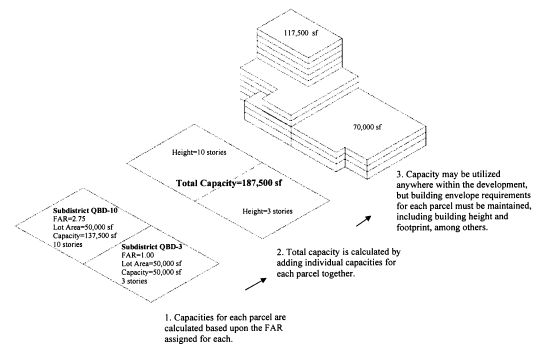
Developments that include more than one subdistrict are permitted. The development capacity shall be calculated separately for each subdistrict portion of the development according to its respective FAR. The development capacity calculated for each subdistrict portion of the development then may be combined to determine the maximum capacity for the entire lot. The capacity may be utilized anywhere within the development, however, building envelope requirements for each subdistrict portion of the development shall be maintained. See Figure IV-1.
Figure IV-1 — Calculation of Development Capacity for Parcels With
Multiple Subdistrict Designations
(5)
Incentive regulations. The incentive regulations provide additional development capacity for particular areas promoting a variety of public benefits such as historic preservation, creation of urban open space, office uses, and affordable housing. Projects participating in an incentive program shall comply with all of the requirements of the DMP urban regulations unless specifically stated by the program. Incentive building requirements tables (Tables IV-41 through IV-53) are provided for each subdistrict subject to incentives and shall supersede the base building requirements tables.
(Ord. No. 4213-09, § 6(Exh. A), 6-29-2009)